START REAL TIME TRACKING
Turns on the Real-Time tracking mode of the application. A Real-Time form (shown below) will open with various options for real-time data collection. This form has the following options:
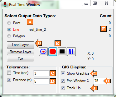
A: Select Output Data Types - You can choose to collect data directly into a Point, Line, or Polygon file. These radio dials toggle between the different shape types.
B: Load Layer - Load a new or existing layer to be used for real-time data collection
C: Time Tolerance - Minimum time between collected points (in seconds)
D: Distance Tolerance - Minimum distance between collected points (in meters)
E: Record Buttons - Used to control data collection in the active layer (A). There are 4 buttons available. They are:
Mark Point - Add most current location to a point layer.
Start Recording - This starts the collection of GPS data for the active layer. If you are recording to a point layer you’ll notice that the Count (F) will begin incrementing for each point recorded. Each point is saved to the layer when it is created. If you are recording to a line or polygon the count will not increment (and will not be saved to the layer) until you stop recording.
Stop Recording - Stops recording and closes the current shape (line or polygon)
Pause Recording - Stops recording of GPS points but does not close the current shape being recorded (line or polygon).
F: Count - Keeps a tally of the number of shapes collected per layer.
G: Show Graphics - If ArcMap is open this option determines whether a “bread crumb trail” will appear in the active mapping window.
H: Pan Window % - Automatically pans if your current location gets too close to the edge of the screen. The Pan Zone % allows you to define how close to the edge of the screen you can get before re-centering the map display. This percentage defines a box as a percentage of the map window for which, if you move outside of it, the map display automatically recenters.
I: Track Up - In ArcMap the Data Frame will display with the track direction up rather than north up.
- Default Fields:
- Click here to get a list of all the information that may be collected in real-time mode and a list of the fields that will be added to your attribute table if they don’t already exist.
Note: All Real-Time points will automatically be added to the GPS data table (one per second) unless a Distance and/or Time tolerance are set. To record directly into a layer you’ll need to follow steps B-E above.